Possible hurricane - 2022 (Ian)

How is the weather now? Are the streets OK? Any chance that you and Connie could just go away for a week?
I'm certainly praying that Ian does not come straight for you, or doesn't gather strength like they describe; the more I read, the more apprehensive I am.
 
How is the weather now? Are the streets OK? Any chance that you and Connie could just go away for a week?
I'm certainly praying that Ian does not come straight for you, or doesn't gather strength like they describe; the more I read, the more apprehensive I am.

The weather is beautiful here right now. As for getting away this week, I wouldn't count on that happening. Connie is going to the hospital to get a port installed on Tuesday for her continued chemo treatment. That gets slid under the skin on her chest and attached to a tube that ties into one of the major arteries going into her heart. Then she has an appointment Wednesday with our new primary care physician, and I have my appointment with same on Friday.

I imagine after her surgery she isn't going to feel much like moving around a whole lot. I won't be at all surprised if she cancels out of her PCP appointment. And I doubt it likely that I will be attending mine if that hurricane is actually going to be making landfall here Friday morning.

What makes me nervous, is that when hurricane Michael was being forecast, they also predicted that it would lose strength before making landfall. And it pretty nearly wiped Mexico Beach right off of the map as a Cat 5 storm. I didn't believe them, so Connie and I bailed out of here and stayed at a motel over on the east coast, out of the way. This time things are complicated for us. But it could be worse. Connie was actually supposed to have her first Doxil treatment on Tuesday with her previous oncologist. That stuff can have some pretty bad side effects. So no good scenarios, only one somewhat better than the other concerning how Connie will likely be feeling this week.

But at least I got the standby generator fixed up and ready in case we have to just hunker down here. Unless a tree falls across it or the propane tank, of course.

If Connie is feeling up to it, I suppose we could just jump into the Grand Cherokee and bug out somewhere. The front seats will fold down flat and would be OK to sleep in if we had to just drive to a rest stop or a Walmart parking lot somewhere out of the target area. But depends on how Connie is feeling then. It is considered minor surgery, but still, getting cut is going to be painful for a while. I watched a video of the procedure, and it certainly doesn't look like any fun to me.

Oh well, we will just have to see what happens. Two of the four models I am watching are still calling for Ian to hit somewhere near Tampa. But by Tuesday or Wednesday I expect the predictions should be more accurate by then.
 
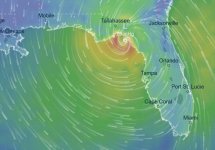
Landfall moving further east. Again. Estimated landfall time is 09-30-2022, 08:00pm, now.
 

Attachments

  • hurricane_09252022_0800pm.JPG
    hurricane_09252022_0800pm.JPG
    45.9 KB · Views: 46
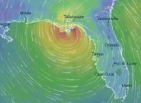
And now West again.... With landfall at 11:00am 09-30. :face_palm_02:
 

Attachments

  • hurricane_09262022_0215am.JPG
    hurricane_09262022_0215am.JPG
    48.4 KB · Views: 40
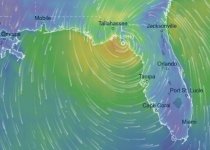
And then back eastward again, with a later landfall time of around 9:00pm on 09-30. :rolleyes:
 

Attachments

  • hurricane_09262022_0950am.JPG
    hurricane_09262022_0950am.JPG
    48 KB · Views: 40
Actually, it looks like they might have just recycled the predicted landfall image from the post I made on 09-25-2022, 08:09 PM. Just looks like the strength of the storm has been reduced a bit. The other models are showing a greatly reduced storm at landfall too. :shrug01:

One would hope this will just fizzle out to being just a modest rain event.
 
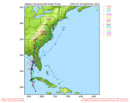
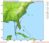
Looking at all of the tracking models, it appears that most are predicting landfall around Tampa Bay. As of today, anyway.
 

Attachments

  • hurricane Ian tracks 09262022.png
    hurricane Ian tracks 09262022.png
    174.3 KB · Views: 41
Looks like they looked real hard at the multiple tracking models and GFS changed their prediction accordingly. Now showing landfall at Tampa Bay on Thursday, 09-29-2022 at 2:00pm.
 

Attachments

  • hurricane_09262022_0210pm.JPG
    hurricane_09262022_0210pm.JPG
    48.3 KB · Views: 43
Naples? That is WAY south of the Tampa Bay area. I don't see any of the forecast tracks headed that way. Of course, some of the later models are now showing tracks further west in my direction. :(
 

Attachments

  • hurricane Ian tracks 09262022_0500pm.JPG
    hurricane Ian tracks 09262022_0500pm.JPG
    82.6 KB · Views: 44
I think a lot of people in lower-lying areas along the coast are being advised to get out. Since the rotation is counter-clockwise and it's coming up from the south, there will be a fairly impressive storm surge.
223342_peak_surge.png
 
Yeah, it looks like that storm is just going to park itself (according to the latest track, anyway) right at the mouth of Tampa Bay for at least 12 hours. Maybe as long as 24 hours. :ack2:
 
Looks like most of the spaghetti models are converging on Tampa Bay for landfall.
 

Attachments

  • hurricane Ian tracks 09272022_1230am.JPG
    hurricane Ian tracks 09272022_1230am.JPG
    85.1 KB · Views: 45
Looks like as of today at 5:00pm, the track is showing landfall at Englewood Beach, FL around 02:00 am on Thursday, 09-29.
 

Attachments

  • hurricane_09272022_0500pm.JPG
    hurricane_09272022_0500pm.JPG
    48 KB · Views: 41
I've been watching this from a distance, and it looks like it was pretty rough on Cuba. Seems like flooding from the storm surge was the worst of it though, and I think you are pretty much away from the coast, right?
Anyway I know the next day or two are going to be rough over there, just hoping it will go over strong but fast and you'll be in the clean up phase as soon as possible.
 
Mandatory evacuation orders issued for Tampa/Naples/Pinellas areas.

Well, it certainly looks like they were correct about extending the evacuation order all the way down to Naples. :shrug01:
 
Please check in and let us know how you and Connie are doing.
 
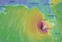
Looks like the hurricane made landfall right up Charlotte Harbor around 3:00 pm today as a Category 4 storm. Wouldn't have been a good time to be on Sanibel Island or Englewood Beach for vacation as Connie and I have done many times in the past. Looks like it will be pretty ugly there through this storm. Probably would be some GREAT shelling on Sanibel afterwards, though.

We are OK up here. Just somewhat breezy, with no rain to speak of in the forecast. Matter of fact, I am watering some of the citrus trees right now. Been pretty dry here for a while now.

Connie had her port surgery yesterday, and I think she would have been OK had we had to evacuate had the storm headed this way. She is a little sore, but not disabled by the surgery. Not that I wish that storm on anyone, but I sure am glad it didn't come this way. We have had enough bad luck for the year, thank you very much.
 
Back
Top